Integrated GeoSpatial Intelligence Solutions for Advanced Monitoring and Decision-Making
GeoAI, or Geospatial Artificial Intelligence, refers to the integration of artificial intelligence (AI) techniques with geospatial data and technologies to analyze, interpret, and extract meaningful insights. It combines machine learning, deep learning, and spatial analytics with data collected from sources like satellites, UAVs, and ground sensors.
Key Components of GeoAI:
- Geospatial Data: Maps, satellite imagery, GPS data, and other spatial information.
- Artificial Intelligence: Algorithms for pattern recognition, prediction, and data analysis.
- Integration of Sources: Combining data from multiple platforms (e.g., satellites, drones, IoT devices).
Applications of GeoAI:
- Environmental Monitoring: Tracking deforestation, water quality, and climate changes.
- Urban Planning: Optimizing infrastructure, traffic systems, and resource allocation.
- Disaster Management: Predicting, monitoring, and responding to natural disasters.
- Agriculture: Precision farming, crop monitoring, and yield prediction.
- Energy and Utilities: Power grid inspections, renewable energy site selection, and resource management.
GeoAI enables organizations to process vast amounts of spatial data efficiently, make informed decisions, and drive innovation across various sectors.
We offers cutting-edge solutions that integrate advanced UAV technology, satellite remote sensing, and ground sensor networks into a unified space-sky-ground sensing system. Our platform leverages Geographic Spatial Intelligence (GeoAI) to provide high-precision mapping, real-time monitoring, and intelligent data analysis. With applications ranging from environmental protection and urban management to infrastructure monitoring and emergency response, HASCO GeoAI empowers organizations with the tools to make data-driven decisions and enhance operational efficiency.

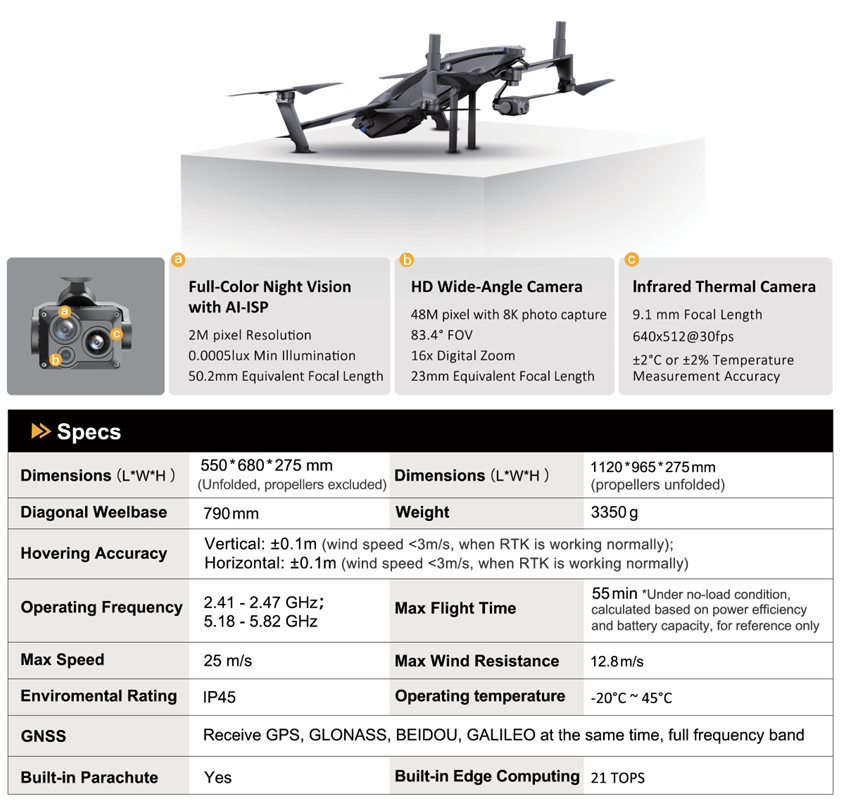
Industry-First Innovative UAV Solutions
Equipped with a fully self-developed 12G/W power system, the UAV significantly reduces energy consumption. Additionally, it boasts a quick-detachable three-sensor or dual-sensor PTZ camera, delivering superior clarity and detailed imagery. With support for multiple mounting options and flexible replacements, this versatile UAV is designed to handle a variety of tasks, making it a one-machine solution for diverse applications.
Our cutting-edge UAV features the industry’s first semi-solid adaptive, fully self-developed flight control system, ensuring more stable flight and enhanced efficiency. The innovative fusion arm-wing quadcopter structure design offers long-range capabilities, while the unimpeded, embedded non-inductive machine parachute guarantees safety and reliability.
Smart Docking Station
Our smart docking station offers customers safe, efficient, and uninterrupted smart patrol services, enabling autonomous drone operations with automatic takeoff, landing, and battery replacement. Designed for industrial-grade performance, it operates in unattended mode, providing continuous support for drone missions. The base station is equipped with a constant temperature and meteorological monitoring system, ensuring stable operations for both the base station and drones in diverse conditions.
Featuring RTK positioning and integrated visual recognition systems, the smart base station enhances the precision of drone takeoff and landing, delivering superior accuracy for industrial applications. This robust solution streamlines operations and ensures reliable, real-time monitoring for a variety of tasks.

Smart Docking Station for DJI Drones
Multifunctional Battery Swap Docking Station – G950. Maximize the capabilities of your DJI M350RTK and M300RTK drones with our advanced medium-sized docking station. Designed for versatility and reliability, this cutting-edge hub combines essential features to support diverse operations in any terrain and weather conditions.
Key Features
- Integrated Weather Station and Monitoring Camera: Stay informed about real-time environmental conditions while ensuring optimal operation and safety.
- Rapid Battery Swaps: Equipped with 4 battery sets, the station enables fast replacements in just 2 minutes, ensuring minimal downtime during critical missions.
- Specialized Payload Support: Handle diverse payloads effortlessly, adapting to various operational needs across industries.
- All-Weather Performance: Built to withstand challenging weather conditions, this docking station ensures consistent and uninterrupted performance.
This all-in-one solution empowers you to achieve comprehensive and efficient operations, unlocking new possibilities for your UAV fleet. Take your drone missions to the next level with our medium-size docking station.

Boost Your DJI Mavic 3 Series with Our Lightweight Docking Station – S310
Enhance your drone’s efficiency with our sleek, lightweight docking station, designed for the DJI Mavic 3 series.
Key Features
- Built-in Weather Station and Monitoring Camera: Get real-time environmental updates.
- Smart Climate Control: Keeps your drone safe and ready to fly.
- Quick Battery Swaps: Swap batteries in under 100 seconds for maximum productivity.
Perfect for inspections, monitoring, and more—this docking station makes your operations faster, simpler, and more effective.

Docking Station for VTOL Drones: Redefining Autonomous Operations – C2000
Our Docking Station for Vertical Takeoff and Landing (VTOL) drones is a game-changing solution for intelligent drone management and operations.
Key Features
- Intelligent Drone Storage: Safe and secure housing for your VTOL drones.
- Autonomous Takeoff and Landing: Fully automated operations with precision control.
- Smart Operations: Handles recovery, charging, and mission management seamlessly.
- Data Transmission & Analytics: Real-time data integration and smart insights for informed decision-making.
Applications
- Extensive Mapping: Efficiently cover large areas with ease.
- Long-Distance Inspections: Ideal for power grids, pipelines, and other remote infrastructure.
- Prolonged Surveillance: Ensure continuous monitoring for security and environmental needs.
This VTOL docking station is designed to meet the demands of diverse scenarios, enabling intelligent and efficient drone operations for mapping, inspections, and surveillance.unlocking new possibilities for your UAV fleet. Take your drone missions to the next level with our medium-size docking station.

UAV Cloud Platform for Comprehensive Management and Remote Sensing Network Development
The UAV cloud platform is designed to support the efficient management of UAVs and the development of regional UAV remote sensing networks. It provides technical assistance for comprehensive UAV scheduling, remote control of unattended systems, and services related to national and regional UAV network remote sensing.
Additionally, the platform plays a key role in the planning and construction of low-altitude air route networks for remote sensing operations. It also facilitates seamless access to the cloud exchange platform for integration with civil aviation systems, ensuring a unified approach to UAV management and airspace coordination.ke your drone missions to the next level with our medium-size docking station.

User-Friendly Web Portal for Comprehensive UAV Management
Users can easily log into a web portal to access a rich and immersive visual environment, enabling them to efficiently manage and monitor UAV operations. The portal supports a variety of tasks, including flight path planning, real-time device monitoring, drone fleet scheduling, data uploading and management, as well as data analysis and application. This centralized platform streamlines business processes, providing users with intuitive control over their UAV networks and enhancing operational efficiency.

Contact Us Today
